Mt. Athos, Greece

In the Chalkidiki region of Northern Greece, the 6670-foot Mt. Athos looms near the tip of the northern most of three tentacle-like peninsulas. Across an area of about 130 square miles, twenty monasteries adorn the base of the mountain, cradled in the arms of plunging valleys, draped over rocky outcrops, sprawled across tawny beaches, and terraced into the shear mountain face. Hundreds of associated buildings tuck into nooks and crannies – dwellings and workshops for small communities of monks, their community churches, and hermit hovels. Continue reading

Foto Friday Favs

Dhofar, Oman

Dhofar, Oman

Amra Castle, Jordan

Amra Castle, Jordan

camel races, Oman

camel races, Oman

Chora Museum, Istanbul, Turkey

Chora Museum, Istanbul, Turkey

Deira, Dubai

Deira, Dubai

Ya'lla group at Karnak Temple in Luxor, Egypt

Ya’lla group at Karnak Temple in Luxor, Egypt

El Aqabat in Egypt's Western Desert

El Aqabat in Egypt’s Western Desert

Fez medina, Morocco

Fez medina, Morocco

Ibn Tulun Mosque, Cairo, Egypt

Ibn Tulun Mosque, Cairo, Egypt

on the Nile in Egypt

on the Nile in Egypt

NAME THAT COUNTRY Episode 55

This rock formation overlooking the Dead Sea is known as Lot’s Wife. Thanks to the shrewd negotiations of Abraham, Lot and his family were spared from the fiery destruction of Sodom but were warned not to look back as they fled. Lot’s Wife, who is never named in the biblical text, did look back and was instantly turned into a pillar of salt. Read more about Sodom and Gomorrah here.

Can you name that country? 
See below for answers.

Continue reading

City of David

The king and his men marched to Jerusalem to attack the Jebusites, who lived there. The Jebusites said to David, “You will not get in here; even the blind and the lame can ward you off.” They thought, “David cannot get in here.”  Nevertheless, David captured the fortress of Zion—which is the City of David. (2 Samuel 5:6-7)

Today, the City of David referred to in the biblical text is an archaeological site and national park that is a must-see for any visitor to Jerusalem. It lies along the spine of a narrow ridge just south of the Temple Mount, a short walk from the Western Wall through the Dung Gate.

The City of David (circled) in a scale model of ancient Jerusalem. It stood alone on that ridge during David's time. His palace, yet to be excavated, is at the north end of the city. Solomon extended the walls north of the palace and built the First Temple atop Mount Moriah, known since as the Temple Mount.

The City of David (circled) in a scale model of ancient Jerusalem. It stood alone on that ridge during David’s time. His palace, yet to be excavated, is at the north end of the city. Solomon extended the walls north of the palace and built the First Temple atop Mount Moriah, known since as the Temple Mount.

The site appears to have been permanently settled by Canaanites as early as the 3rd millennium BCE. The 3,800 year old Spring Citadel is a Canaanite fortress built outside the eastern wall to protect the Gihon Spring, the city’s main source of water. This is the largest known Canaanite fortress in Israel, with walls 23 feet thick surrounding the spring. It is believed to be the “fortress of Zion” taken by David to conquer the city in 1004 BCE. It was only discovered in 1995 and opened to the public in 2014 after 17 years of excavation.

King David made the city his capital and proceeded to unite the people of Israel for the first time. David’s son King Solomon extended the city to include the Temple Mount and built the First Temple there.

City of David archaeological park, Jerusalem - This is how it looks today, more or less, excavations are on-going.

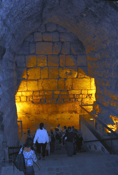
City of David archaeological park, Jerusalem – This is how it looks today, more or less, excavations are on-going.

Begin the tour of the City of David at the visitor center, where you can view a 16-minute, 3-D film showing the city as it looked in its prime. Then, if you’re not claustrophobic, explore the tunnels of the city.

There’s the Canaanite tunnel, which most archaeologists date to the 18th century BCE, around the same time the Spring Fortress and other fortifications were built.

Warren’s Shaft, discovered in the 19th century by Sir Charles Warren, is a 40-foot vertical piece of the Canaanite water system that may have been used by David’s army to enter the city.

Hezekiah’s tunnel, also known as the Tunnel of Siloam or Shiloh, is a later addition
built in the early 8th century BCE on the orders of King Hezekiah. Its purpose was to join the Gihon Spring to the city, so it would have an internal water source during the Assyrian siege.

Water still runs through this tunnel today, about 2 feet deep. If you don’t mind wading, it’s a fascinating walk. So sophisticated were their calculations, diggers started on either end and met within millimeters of each other in the middle. You can still see in the tunnel where they marked the meeting point. The tunnel connects the Gihon Spring, which lies outside the city walls, to the Siloam Pool inside the walls. In the winter, we usually bypass this tunnel because the water is quite cold and can be too deep.

wading through Hezekiah's Tunnel - cityofdavid.org.il

wading through Hezekiah’s Tunnel – cityofdavid.org.il

Yet another tunnel, newly opened, the Pilgrim’s Tunnel leads from the City of David to the Davidson Center, which is just south of the Western Wall Plaza. This tunnel was dug during the Herodian Period in the 1st century BCE as a drainage channel to capture water flowing off the surrounding mountains. Water was directed away from the grand Herodian Road, which formed the ceiling of the tunnel, and into the Siloam Pool. Pilgrims from all over Israel would stop at the pool to cleanse themselves before walking the Herodian Road up to the Temple (by now, the 2nd Temple). The Herodian Road is under excavation but visitors today can walk the same route under ground through the tunnel.

The City of David is not a large area but touring the site involves quite a lot of stairs up and down and tunnels require some ducking in places.

There is a parking lot on-site.

NAME THAT COUNTRY Episode 54

For thousands of years, Hathor was one of the most beloved goddesses of our mystery country. Her attributes and powers broadened over the centuries as she mingled with and absorbed a number of other deities. She was “the mother of mothers,” patron of women, fertility, childbirth and children. As the “mistress of life,” she represented joy, love, beauty, art, music and dance. She was a sky goddess, who gave birth to the sun god Ra each morning and conceived the coming day with him each night. In the underworld, she welcomed the souls of the newly dead with motherly reassurance as they made their way to eternal judgement. She was often represented as a cow or as a woman with cow ears, as above in the Chapel of Hathor at the Temple of Hatshepsut near Luxor.

Can you name that country? 
See below for answers.

Continue reading

Jerusalem Underground – Western Wall Tunnels

Western Wall Prayer Plaza, Jerusalem

As the ancient remains closest in proximity to the last temple, the Western Wall in Jerusalem is the most important holy site for Jews. It’s the western retaining wall to the Temple Mount, upon which the Temple once stood. The temple itself was destroyed by the Romans in 70 CE.

The Western Wall is generally known as the 200-foot long expanse presiding over the open-air Prayer Plaza. But another 1050 feet of wall extends to the north of the plaza beneath streets and buildings in the Muslim Quarter. Excavation of the area began in the mid-19th century but was limited by Ottoman rulers. Excavation started up again in earnest after Israel took control of the Old City in 1967 and continues still today.

Tunnel tours explore the buried section of the Wall, as well as original steps that lead from the city level up to the Temple Mount, Roman streets, 2nd-Temple era dwellings and ancient cisterns. A section of wall within the tunnels known as Opposite Foundation Stone is especially sacred. It is traditionally held to be the point closest to the heart of the Temple, the Holy of Holies. 

In this illustration of the Temple Mount before the Temple was destroyed, the modern prayer plaza lies between the two arches and the tunnel follows the buried section of the wall to the north of the far arch.

Tunnel tours begin on the north side of the Western Wall Plaza and end near the 1st Station of the Cross on the Via Dolorosa.

NAME THAT COUNTRY Episode 53

The 14th-century Bou Inania medersa (or madrasa) and mosque in the heart of the Fez medina is, historically, one of the most important Koranic schools in our mystery country and one of the few religious places open to non-Muslim visitors.The cool, quiet courtyard and interiors feel worlds away from the mad crush of the surrounding city.
The image above can only hint at the incredible aesthetics of Bou Inania, with its intricately carved cedar and plaster and colorful tiles.

Can you name that country? 
See below for answers.

Continue reading

WOW Places – the theater at Pergamum, Turkey

The world’s steepest ancient theater appears to be sliding right off the acropolis of Pergamum. Don’t worry, it has been hanging on for 2,000 years. Imagine all the many thousands of performances staged right here, with the sweeping valley view as a backdrop. Just out of the picture, dazzling marble remains are scattered across the mountain top; and the Temple of Dionysus, the foundations of the great Alter of Zeus and the agora are terraced into the slope off to the side.

YIKES!

Pergamum was an important Greco-Roman city, home to 200,000 people at its peak. The 3rd largest library of antiquity was here and people from all across the Roman world came for health and wellness treatments at the Sanctuary of Asclepius. One of the Seven Churches of Revelation was in Pergamum and it’s a common stop on Christian pilgrimage tours of Turkey.

Pergamum is about 15 miles from the Aegean coast, 60 miles from Izmir, the closest airport, and 110 miles from Ephesus. The modern town on the site is Bergama.

Click to read more about Pergamum.