NAME THAT COUNTRY


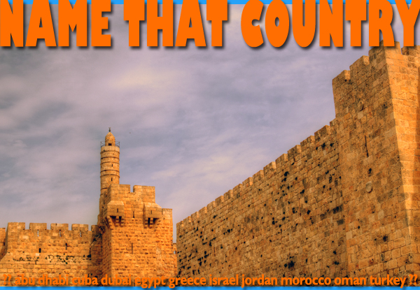
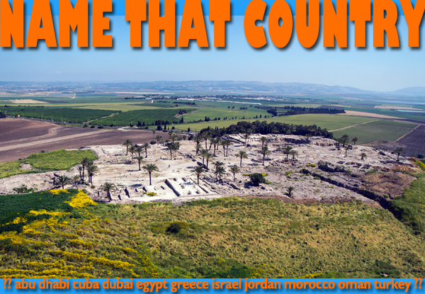
These caves are named for the ancient settlement just below. They’re located in the Judean Desert, about a mile from the Dead Sea and about an hour’s drive from Jerusalem. In 1947, a local Bedouin boy found a cache of ancient scrolls in one of the caves while searching for a wayward goat. Subsequent excavations yielded nearly 900 scrolls in 11 caves. Scholars are still studying the manuscripts, many in fragments, today. Some of the scrolls can be seen at the Israel Museum’s Shrine of the Book in Jerusalem.


Can you name that site? 
See below for answers.


Continue reading

NAME THAT COUNTRY


As our guide Jacob will tell you, Beit She’an (aka Scythopolis) is one of the world’s most extensively excavated Greco-Roman sites. Blessed with fertile land and abundant water, this strategic location at the convergence of the Jordan and Jezreel Valleys has been occupied at least since the 5th millennium BCE and holds remains from Canaanites, Egyptians, Philistines, Israelites, Greeks, Romans and Byzantines in 18 distinct layers. At its peak, as the main Roman Decapolis city, Beit She’an had a population of 40,000.


Can you name that country? 
See below for answers.


Continue reading

NAME THAT BODY OF WATER

The inland sea pictured above forms part of the border between Israel and Jordan. This sea lies at the lowest elevation on earth, over 1,300 feet below sea level at the surface. Due to a unique mineral content, the sea water and mud are prized for their therapeutic qualities. The extreme salinity of the water makes it very difficult to sink. Bathers bob on the surface effortlessly. Atmospheric conditions here also have health benefits. High levels of oxygen are both invigorating and relaxing. It’s really a magical place. The sea is centrally located and makes an easy stopover between visits to other top tourist attractions. It also makes a good base for visiting a number of tourist sites.


Can you name that body of water? 
See below for answers.

Continue reading

NAME THAT COUNTRY

This is one of some 800 Bell Caves in the Beit Guvrin-Maresha National Park in the central part of our mystery. The caves were chalk mines dug in the 7th-11th centuries, during the country’s Islamic period. Miners would first dig a shaft and then cut blocks out of the soft chalk walls and haul it up through the shaft with ropes. Chalk was used in construction.


Can you name that country? 
See below for answers.


Continue reading

NAME THAT COUNTRY

This stretch of the Kidron Valley lies between Mount Moriah and the Mount of Olives in one of the world’s holiest cities. The valley continues eastward about 20 miles to the Dead Sea. The valley and adjacent slopes have been burial grounds for thousands of years due to their association with End Times in Judaism, Christianity and Islam.


Can you name that country? 
See below for answers.

Continue reading

NAME THAT COUNTRY

Byzantine Christians named this ancient citadel The Tower of David because they mistakenly understood one of the Herodian watchtowers to have been built by the 2nd king of the land. In modern times, the Tower of David refers to the 17th-century Ottoman minaret, which adjoins the Mamluk mosque built within the citadel grounds. Today, the Tower of David is a museum, with historical, cultural and art exhibits, as well as activities and lectures.

Can you name that country? 
See below for answers.

Continue reading

NAME THAT COUNTRY

The Western Wall, built around 19BCE, is among the world’s most holy places, but much of it is hidden behind unrelated structures built up against it over the centuries. The section commonly known as the Western Wall is only about 200 feet of a total length of 1600 feet . Fifty years ago tunnel excavations began to reveal the full length of the wall, as well as the lower 17 courses below modern street level. One of many interesting things uncovered in 20 years of digging is the wall’s largest stone, which is 45 feet long, 10 feet tall and weighs 570 tons!


Can you name that country? 
See below for answers.

Continue reading

NAME THAT COUNTRY

When Jesus was 30 years old, he left Nazareth and settled in the village of Capernaum, about 30 miles away. The village sits on the northern shore of the Sea of Galilee, which is actually a fresh water lake, known locally as Lake Kinneret. Several of Jesus’ disciples lived in Capernaum and fished in the lake for a living. The synagogue pictured above post-dates Jesus but is built on remains of a synagogue where he certainly preached.

Can you name that country? 
See below for answers.

Continue reading

NAME THAT COUNTRY Episode 129

Biblical wisdom is timeless, but it is often expressed in the activities and settings of very particular times and places. In the northern Galilee region of our mystery country, Nazareth Village provides visitors with living context for some familiar ancient stories.
Visitors observe and participate in daily chores performed in the manner of 1st-century Galilean villagers. Tending animals and crops, pressing olive oil, baking bread… The village buildings and methods of farming and household tasks are based on scholarly research and archaeological evidence.

Can you name that country? 
See below for answers.

Continue reading

NAME THAT COUNTRY Episode 123

Over 20 layers of habitation, one atop the other, make up Tel Megiddo in the north of our mystery country. An important Egypt-Mesopotamia trade route crossed the Carmel Mountain ridge at a pass near the settlement. This is Armageddon (Greek for Megiddo) of the Book of Revelation, where the final battle between the forces of good and evil is prophesied to take place.

Can you name that country? 
See below for answers.

Continue reading